How Landmen Are Using the PLSS API for APD Workflows
Land departments use the Township America PLSS API to convert legal descriptions to GPS coordinates for APD filings. One endpoint, GeoJSON out.
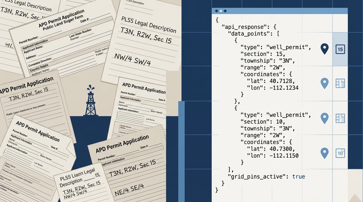
A land department processing 50 APD locations per week knows the bottleneck. The well site descriptions come in as PLSS legal descriptions (aliquot parts like T4N R5E Sec 12 NE, 6th Principal Meridian), and the BLM Form 3160-3 needs verified GPS coordinates. Someone has to look each one up. Multiply that by a dozen active drilling programs across Wyoming, Oklahoma, and North Dakota, and the manual coordinate lookup becomes the thing that slows everything else down.
The Township America PLSS API replaces that manual step with a single HTTP call: legal description in, GeoJSON coordinates out.
The APD coordinate problem
Every Application for Permit to Drill filed with the BLM or a state oil and gas commission requires the well site location in both PLSS notation and geographic coordinates. The PLSS description is typically on the lease or the geologist's prospect report. For older leases, the original description may trace back to a GLO patent in BLM's online archive. The GPS coordinates are not included. Someone (usually the landman or a GIS analyst on the team) has to convert one to the other.
For a single well, that is a minor task. For a land department running 50 or more APDs per week across multiple basins, it adds up fast. A transposed range number (5E instead of 4E, for example) puts the well site six miles off. That is a BLM resubmission, a permit delay, and a rescheduled field crew. For a closer look at how these coordinate-offset errors happen and why data source matters, see why approximate PLSS conversion isn't good enough.
One endpoint, one request
The Township America Search API takes a PLSS legal description and returns a GeoJSON FeatureCollection with the parcel centroid, polygon boundary, state, county, and principal meridian. Here is a Python example converting a Wyoming well location:
import requests

response = requests.get(
    "https://developer.townshipamerica.com/search/legal-location",
    params={"location": "T4N R5E Sec 12 NE Wind River Meridian"},
    headers={"x-api-key": "your-api-key"},
)

data = response.json()
coords = data["features"][0]["geometry"]["coordinates"]
print(f"Latitude: {coords[1]}, Longitude: {coords[0]}")
That is the entire workflow for one location. The response includes the centroid coordinates, the section polygon in GeoJSON, and the full legal description string: everything a landman needs to fill in the coordinate fields on an APD form.
If your team uses Python, the townshipamerica SDK wraps this in a typed client with Pydantic models: pip install townshipamerica, four lines of code, GPS coordinates back. The Python PLSS SDK page has batch and GeoPandas examples ready to copy.
Batch processing: 500 APD locations in five requests
The real time savings come from batch conversion. Instead of looping through one location at a time, the Batch API endpoint accepts up to 100 PLSS descriptions per request. A land department with a CSV of 500 well locations can split it into five requests and have every coordinate back in seconds.
from townshipamerica import TownshipAmerica

client = TownshipAmerica(api_key="your-api-key")

# 100 well locations from an APD spreadsheet
well_sites = [
    "T4N R5E Sec 12 NE Wind River Meridian",
    "T3N R4E Sec 1 SE Wind River Meridian",
    "T5N R6E Sec 24 SW Wind River Meridian",
    # ... up to 100 per batch
]

results = client.batch_search(well_sites)

for result in results:
    centroid = result.centroid
    print(f"{centroid.properties.legal_location}: "
          f"{centroid.geometry.latitude}, {centroid.geometry.longitude}")
No credit-based limits. No per-conversion fees. The Batch API plan starts at $40/month for 1,000 requests, enough for most mid-size land departments.
Coverage: 30 states, all 37 principal meridians
The PLSS API covers every PLSS state and all 37 principal meridians, from the Cimarron Meridian in Oklahoma to the Wind River Meridian in Wyoming to the 6th Principal Meridian across Kansas and Nebraska. Every conversion pulls from official BLM CadNSDI data, the same dataset federal and state agencies reference.
That coverage matters for land departments working across multiple basins. A company with drilling programs in the Powder River Basin (Wyoming), the STACK play (Oklahoma), and the Williston Basin (North Dakota) needs a single API that handles all three without switching tools or worrying about meridian coverage gaps.
Fitting the API into existing systems
Most land departments are not starting from scratch. They have internal land management databases, GIS platforms, or custom tools built on spreadsheets and Access databases that have worked for years. The PLSS API fits into those systems as a coordinate lookup service:
- Internal land databases: Add a column for GPS coordinates. When a new lease or APD record is entered with a PLSS description, call the API to populate the coordinates automatically.
- GIS pipelines: Feed PLSS descriptions from regulatory filings into the API, get GeoJSON back, load directly into ArcGIS, QGIS, or any tool that reads GeoJSON.
- Field operations: Build a simple script or internal web tool that lets field crews verify a PLSS description before driving to a well site. A wrong quarter section caught before the truck rolls saves a day. The same principle applies to construction site managers who need GPS coordinates from permit legal descriptions before mobilizing excavation crews.
The API returns standard GeoJSON, so it works with any mapping or GIS tool without format conversion. For land departments that start their title work from original GLO patents, our field guide to navigating BLM GLO records walks through the full workflow from historical survey plat to GPS coordinates. For teams building more involved integrations, the API documentation covers authentication, response formats, rate limits, and error codes.
Why not Regrid or LegalLandConverter?
Regrid is a parcel data provider. It serves county tax parcel boundaries, not PLSS parsing. If you send it "T4N R5E Sec 12 NE Wind River Meridian," it will not return a coordinate. It solves a different problem.
LegalLandConverter does parse PLSS, but it uses a credit-based pricing model. For a land department doing hundreds of conversions weekly, credits run out fast and the per-conversion cost climbs.
Township America's PLSS API is built specifically for PLSS-to-GPS conversion at volume. Flat monthly pricing, no per-lookup fees, and an endpoint designed for the exact input format landmen already have on their desks.
Getting started
The API is live at townshipamerica.com/api. The Search API starts at $20/month for 1,000 requests. The Batch API starts at $40/month. No contracts, no setup fees, and a 30-day money-back guarantee.
If your land department is still converting PLSS descriptions by hand, or paying per-credit for a tool that was not built for volume, it is worth running a test batch through the API. The oil and gas industry page has more context on how O&G teams are using Township America, and the batch conversion guide walks through the full CSV workflow.
If you are building an AI assistant to draft APDs, the same coordinate step is available as an agent tool: the PLSS MCP server lets a language model verify each Section-Township-Range mid-task, no HTTP call to write yourself.
One endpoint. PLSS in, coordinates out. That is the entire pitch.