Navigating BLM GLO Records in 2026: A Field Guide
How to search BLM GLO records, read historical survey plats, and convert GLO legal descriptions to GPS coordinates for title work.
You are three layers deep in a title chain for a 640-acre tract in eastern Montana. The modern county records go back to 1952. Before that, you need the original patent, and that means the Bureau of Land Management's General Land Office records. Every landman and title examiner working federal or formerly federal land hits this step eventually. Knowing how to run a BLM GLO records search efficiently is the difference between a two-hour title rundown and a two-day one.
What Are GLO Records and Why Every Landman Needs Them
The General Land Office was the federal agency that surveyed and disposed of public domain lands from 1812 until it merged into the BLM in 1946. Its records (original survey plats, field notes, land patents, and mineral surveys) are the foundation of land title in the 30 PLSS states. If you are examining title to any parcel that was once public domain, the GLO patent is the root of the chain.
These records document the first legal transfer of land from the federal government to a private party. Homestead patents, cash entries, railroad grants, and mining claims all originated as GLO transactions, and all reference the parcel by its PLSS legal description: Township, Range, Section, and principal meridian.
For landmen working oil and gas leases, GLO records answer a critical question: did the original patent reserve mineral rights to the federal government? Many patents issued after 1916 contain a mineral reservation clause. Missing that clause during title examination means missing a federal mineral interest, which can unravel an entire lease position.
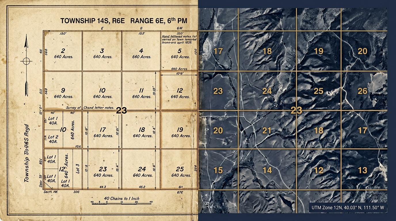
How to Search GLO Records Online
The BLM maintains GLO records through its online portal at glorecords.blm.gov. The core BLM GLO records search workflow is straightforward once you know the interface.
Start with what you know. If you have the legal description (say, T15N R48E Sec 22, Principal Meridian Montana), enter it directly in the Land Patent Search. The system returns every patent issued for that section: patentee name, patent date, authority (Homestead Act, Desert Land Act, etc.), and the document image.
If you only have a patentee name, use the Name Search. Keep in mind that spelling variations were common in 19th-century records. "Johanssen" might appear as "Johannsen" or "Johansen." Try multiple variations.
For the survey plats and field notes, use the Survey Search. Enter the township and range (T15N R48E, Principal Meridian Montana) and the system returns every survey plat filed for that township. These plats show the original section boundaries as the surveyor ran them, including any lot numbering along rivers, lakes, or state boundaries where standard 640-acre sections could not be laid out.
Reading Historical Survey Plats: Extracting Legal Descriptions
GLO survey plats are hand-drafted maps from the original federal surveys. They show section lines, lot boundaries, topographic features, and the surveyor's notes about terrain and vegetation. For title work, the key information is the lot and section numbering.
Standard sections are straightforward: 36 numbered sections per township, each roughly one mile square. But fractional sections along water bodies or state lines are divided into lots instead of standard quarter sections. A patent for "Lot 3, Sec 18, T15N R48E, Principal Meridian Montana" only makes sense if you can see on the plat where Lot 3 falls within that section.
When reading a plat, look for:
- Section numbering: confirms the survey follows the standard serpentine pattern
- Lot boundaries: irregular parcels along section edges, typically near rivers or lakes
- Meander lines: the surveyor's traverse along navigable water, which may differ from the actual bank
- Mineral survey markers: small numbered claims overlapping the section grid, common in Montana, Colorado, and Nevada
- Correction lines: standard parallels and guide meridians where accumulated survey error was corrected
Cross-reference the plat descriptions with the patent records. If the patent says "NW quarter of Section 22," the plat should confirm that Section 22 is a standard section with four full quarter sections. If it is fractional, the patent language should reference lots instead.
Converting GLO Legal Descriptions to GPS Coordinates
Once you have extracted the legal descriptions from GLO records, you need coordinates. Title opinions, GIS overlays, and field verification all require latitude and longitude, not just a township-range-section reference.
This is where the original survey records and modern coordinate systems meet. A patent description like T15N R48E Sec 22 NE, Principal Meridian Montana identifies a specific 160-acre quarter section in Dawson County. Converting that to GPS coordinates requires accurate PLSS boundary data tied to the correct principal meridian.
Township America's PLSS converter handles this directly. Enter the legal description from the GLO record, and you get the parcel centroid, boundary polygon, county, and state. Output formats include GeoJSON, KML, and Shapefile for direct import into your GIS. The API does the same thing programmatically for land departments processing dozens of GLO-referenced parcels at once.
For title examiners working a single chain, the converter is a fast way to verify that a GLO patent description and a modern county record are referencing the same physical ground. For landmen running BLM GLO records search across an entire drilling prospect (say, 40 sections in the Williston Basin), the batch conversion tool processes the full set in one step.
Building a Full Title Chain: From Original GLO Survey to Modern PLSS
A complete title chain starts with the GLO patent and runs forward through every conveyance to the present owner. Each link in that chain references the same PLSS legal description, or should. Errors creep in when descriptions are transcribed incorrectly across deeds, or when a fractional lot number from an 1880s survey gets replaced with a quarter-section call that does not match the original plat.
Here is a practical workflow for building a title chain from GLO records:
- Search GLORECORDS for all patents in the target section. Note the patentee, date, authority, and exact legal description.
- Pull the survey plat for the township. Confirm that the patent descriptions align with the platted section and lot layout.
- Convert the GLO legal descriptions to GPS coordinates using Township America. Verify that the patent parcels cover the ground you expect.
- Run the chain forward through county records, matching each conveyance back to the original GLO description.
- Flag discrepancies: any deed that uses a different legal description format (quarter-section vs. lot) or references a different meridian than the GLO patent.
This workflow applies whether you are examining title for an APD filing, a mineral lease acquisition, or a BLM right-of-way application. The GLO record is always the starting point.
Start With the Patent
Every title chain on formerly federal land begins with a GLO patent. Knowing how to search those records, read the original survey plats, and convert the legal descriptions to coordinates is a core skill for landmen and title examiners.
If you are working through a BLM GLO records search and need to convert the descriptions you find, try the PLSS converter or check the API documentation for batch workflows.