Reading Legal Land Descriptions on Construction Permits: A Field Guide
Learn how to read PLSS legal land descriptions on construction permits. Township, range, section, and quarter section decoded for contractors and site managers.
A site manager in Colorado picks up a grading permit for a commercial pad site. The legal description on the application reads T2S R68W Sec 22 NE¼, 6th Principal Meridian. He needs to get a crew out there Monday morning, but he has never parsed one of these descriptions before. The permit does not include a street address, just that string of letters and numbers. This is a common situation during spring groundbreaking season, when municipal planning offices across PLSS states process their highest volume of construction permit PLSS legal descriptions between March and May.
If you work in construction in any of the 30 PLSS states, you will encounter these descriptions on grading permits, building permits, utility easements, and site plans. Here is how to read them.
What Each Piece of a PLSS Description Means
A construction permit PLSS legal description breaks down into five parts. Take the example from that Colorado building permit:
T2S R68W Sec 22 NE¼, 6th Principal Meridian
- T2S: Township 2 South. The "T" stands for township, a 6-mile-wide horizontal row. "2S" means two rows south of the baseline. Townships are numbered north or south from a reference line.
- R68W: Range 68 West. The "R" stands for range, a 6-mile-wide vertical column. "68W" means 68 columns west of the principal meridian.
- Sec 22: Section 22. Each township is divided into 36 sections, each approximately one square mile (640 acres). Sections are numbered 1 through 36 in a specific serpentine pattern.
- NE¼: Northeast quarter. This subdivides the 640-acre section into a 160-acre quarter. The four quarter sections are NE, NW, SE, and SW. Some permits go further. NENE means the northeast quarter of the northeast quarter, a 40-acre parcel.
- 6th Principal Meridian: The reference line from which the township and range are measured. Colorado uses the 6th Principal Meridian. Every PLSS state is tied to one or more of the 37 principal meridians across the US.
Together, these five elements pinpoint a specific piece of land. That Colorado permit description identifies a 160-acre quarter section southeast of Denver, near the intersection of township and range grid lines that have been in place since the original government survey.
For a full breakdown of how the township and range system works, including section numbering and quarter section diagrams, see our reference guide.
Reading the Description on the Actual Permit
Construction permits do not always format PLSS descriptions the same way. You will see variations across counties and states:
- Full notation: The Northeast Quarter of Section Twenty-Two, Township Two South, Range Sixty-Eight West of the Sixth Principal Meridian
- Abbreviated: NE¼ Sec 22, T2S R68W, 6th PM
- Condensed: NE 22 2S 68W 6th Principal Meridian
- With county: NE 22 2S 68W, Douglas County, Colorado
All four describe the same 160-acre parcel in Colorado. The key is identifying the five components (quarter section, section number, township, range, and principal meridian) regardless of how the permit formats them.
Municipal planning offices in different counties use different formats. Some include the principal meridian; some assume you know it from the state. If the meridian is missing and you are working in a state with more than one (Oklahoma has the Indian Meridian and the Cimarron Meridian, for example), you need to confirm which one applies before navigating to the site.
Common Errors That Send Crews to the Wrong Location
Three mistakes account for most field navigation problems when working from construction permit PLSS legal descriptions:
1. Confusing quarter sections. NE¼ and NW¼ of the same section are a half mile apart at minimum. On a 640-acre section, that is the difference between showing up at the correct pad site and pulling into someone else's property. Always double-check which quarter the permit specifies.
2. Using the wrong principal meridian. If a permit in Oklahoma reads T17N R3W without specifying the meridian, the location under the Indian Meridian and the Cimarron Meridian will be in completely different parts of the state. States with multiple meridians require extra attention: Wyoming (Wind River and 6th Principal), California (Mount Diablo, San Bernardino, Humboldt), and Alaska (five meridians).
3. Misreading direction letters. T17N R3W (Township 17 North, Range 3 West) and T17S R3E (Township 17 South, Range 3 East) are hundreds of miles apart. One transposed letter on a permit application puts the project in the wrong county.
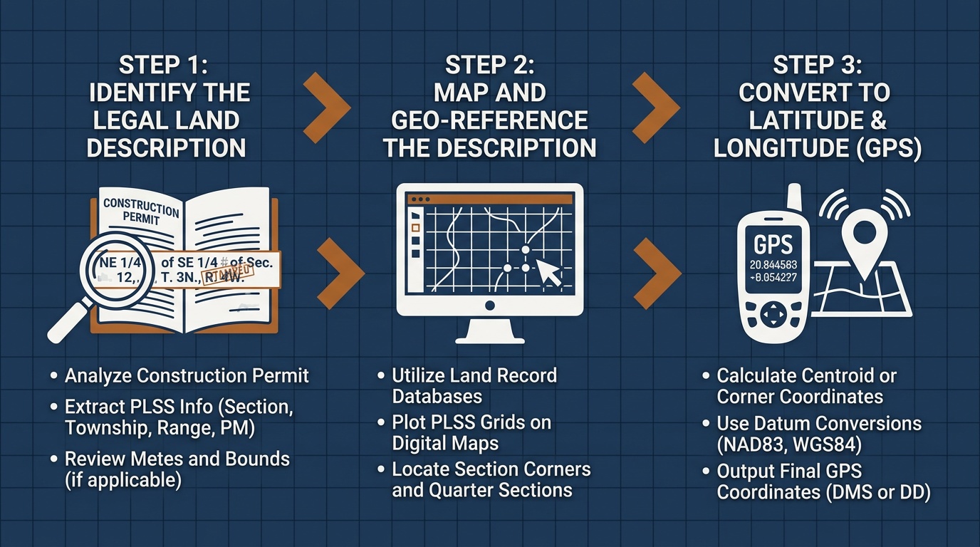
Converting a Permit Description to GPS for Site Navigation
Once you have parsed the PLSS description from a construction permit, you need GPS coordinates to actually drive to the site. That is where the description stops being a reference and starts being a route.
Take the Colorado example, T2S R68W Sec 22 NE¼, 6th Principal Meridian. Paste that into a PLSS converter and you get the latitude and longitude for the center of that quarter section: coordinates your phone's navigation app can use directly.
For site managers running multiple permits, the pattern repeats: pull the legal description from each permit, convert to GPS, and send coordinates to the field crew. If you are managing a subdivision or a multi-phase commercial project, a batch conversion can handle all the legal descriptions at once: upload a CSV, get GPS coordinates back for every parcel.
Spring Groundbreaking Season and Permit Volume
March through May is when municipal planning departments process the bulk of construction permits for the year. Contractors break ground as weather allows, and the permit applications stack up. Each one carries a PLSS legal description that someone on the team needs to verify and convert to a field-navigable location.
For general contractors and permit coordinators who handle dozens of permits per month across multiple counties, reading these descriptions accurately is not optional. It is the difference between a job that starts on time and a crew that drives to the wrong section.
From Permit to Coordinates in One Step
Township America's PLSS converter takes any legal land description format (full notation, abbreviated, or condensed) and returns GPS coordinates calculated from official BLM PLSS data. All 30 PLSS states, all 37 principal meridians. Type in the description from the permit, get coordinates back, and send your crew to the right spot.
If your team processes construction permits in PLSS states, it is worth bookmarking the converter for the states you work in most: Oklahoma, Colorado, or any of the 30 states covered. One description in, one coordinate out.