How Big Is a Township? Acres, Sections, and Size Explained
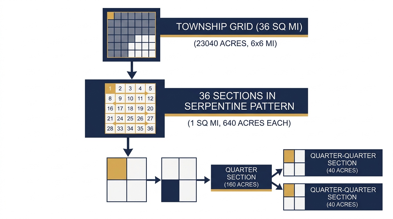
A PLSS township is 6 miles by 6 miles: 36 square miles containing 36 sections and 23,040 acres. Here's how the grid breaks down from township to quarter section.
You are looking at a deed, a drilling permit, or a crop insurance filing, and it references "T4N R5E, Sixth Principal Meridian." You know that points to a township somewhere in Kansas, but how much land does that actually cover? How many acres? How many sections fit inside it?
These are practical questions that come up daily for real estate professionals, GIS analysts, and anyone working with the Public Land Survey System. Here is the straightforward answer, plus the detail behind it.
The Quick Answer: 36 Square Miles, 23,040 Acres
A standard PLSS township is a square measuring 6 miles by 6 miles. That gives it a total area of 36 square miles, or approximately 23,040 acres. Each township contains exactly 36 sections, and each section is 1 mile by 1 mile (640 acres).
To put that in perspective, a single township is roughly the size of a small county subdivision. It is large enough to contain dozens of farms, several oil well pads, or an entire rural community.
How the Township and Range Grid Works
The PLSS divides land across 30 US states into a rectangular grid anchored to 37 principal meridians. The grid works on two axes:
- Township tiers run east-west in 6-mile-wide horizontal strips, numbered north or south from a baseline. T4N means the fourth strip north of the baseline.
- Ranges run north-south in 6-mile-wide vertical columns, numbered east or west from the principal meridian. R5E means the fifth column east of the meridian.
Where a township tier and a range intersect, you get a township: that 6-by-6-mile block. The full reference includes the governing meridian: T4N R5E, Sixth Principal Meridian places you in Republic County, Kansas.
This grid covers everything from the plains of Nebraska to the forests of Oregon. If you need to find the township and range for a specific location, you can look it up by coordinates or address.
How Sections Are Numbered Inside a Township
Each township is divided into 36 sections, numbered in a serpentine (boustrophedon) pattern starting at the northeast corner:
 6 |  5 |  4 |  3 |  2 |  1
 7 |  8 |  9 | 10 | 11 | 12
18 | 17 | 16 | 15 | 14 | 13
19 | 20 | 21 | 22 | 23 | 24
30 | 29 | 28 | 27 | 26 | 25
31 | 32 | 33 | 34 | 35 | 36
Section 1 sits in the northeast corner. The numbering snakes left across the top row (1 through 6), drops down, runs right across row two (7 through 12), and continues alternating until Section 36 in the southeast corner.
This pattern has been standard since the Land Ordinance of 1785. If someone references Section 16 in a legal description (like Sec 16, T15N R2E, Indian Meridian in central Oklahoma), you immediately know it sits near the center of the township. Section 16 was historically reserved as the "school section" in many states, set aside to fund public education.
Quarter Sections and Aliquot Parts: Breaking Down the 640 Acres
A full section is 640 acres, but most land transactions deal with smaller parcels. The PLSS subdivides sections into progressively smaller pieces called aliquot parts:
| Subdivision | Size | Acres |
|---|---|---|
| Section | 1 mi x 1 mi | 640 |
| Quarter section (NE, NW, SE, SW) | 1/2 mi x 1/2 mi | 160 |
| Quarter-quarter section (e.g., NENE) | 1/4 mi x 1/4 mi | 40 |
| Quarter-quarter-quarter (e.g., NENENE) | 1/8 mi x 1/8 mi | 10 |
A description like SWNE Sec 22, T3S R68W, Sixth Principal Meridian points to the Southwest Quarter of the Northeast Quarter of Section 22: a 40-acre parcel in Elbert County, Colorado. That is 1/16th of a section and 1/576th of the entire township.
These subdivisions matter because they are the language of deeds, mineral leases, and government filings across all 30 PLSS states.
Why Township Size Matters in Practice
Understanding how big a township is has direct consequences for land professionals:
Real estate and title work. When a county assessor references T2N R3W, you need to know that covers 23,040 acres, not a single parcel. The section and quarter-section narrow the location. Missing that distinction can send you to the wrong property entirely.
Permits and regulatory filings. Drilling permits from the BLM, county building permits, and USDA program enrollments all use PLSS descriptions. A permit for NW Sec 9, T21N R105W, Wind River Meridian in Fremont County, Wyoming specifies a 160-acre quarter section; verify the boundaries before breaking ground.
Crop insurance and USDA programs. The Risk Management Agency (RMA) and Farm Service Agency (FSA) identify enrolled acreage by section, township, and range. If your filing says Section 14 but your field is actually in Section 15, the claim gets denied. The difference between adjacent sections is a full mile. Verifying quarter sections before the filing deadline saves real money.
GIS and mapping. Analysts working with PLSS data need to know that a township boundary encloses 36 square miles. When you batch convert PLSS descriptions for a project area, each township reference covers a significant footprint on the map.
Not Every Township Is a Perfect Square
In theory, every township is exactly 6 by 6 miles. In practice, the curvature of the earth forces adjustments. Meridian lines converge as they approach the poles, which means the north edge of a township is slightly narrower than the south edge. The PLSS accounts for this with correction lines (standard parallels) placed every 24 miles.
Sections along the north and west edges of a township absorb the accumulated error. That is why you will occasionally see sections that are 650 acres or 630 acres instead of the standard 640. Government lots (irregular parcels along rivers, lakes, and state boundaries) also deviate from standard sizes.
Despite these variations, the 6-mile, 23,040-acre standard holds as the baseline for the entire system.
Convert Any Township to Coordinates
If you have a township and range reference and need to see exactly where it falls on a map, the PLSS converter turns any legal land description into latitude and longitude, down to the quarter-quarter section level. Enter something like T15N R2E Sec 22 NE, Indian Meridian and get the precise centroid coordinates, boundary polygon, and acreage for that parcel.
For teams processing multiple descriptions at once, batch conversion handles CSV uploads across all 30 PLSS states and 37 principal meridians.