GPS to PLSS Reverse Lookup: Converting Coordinates to a Legal Land Description
Reverse PLSS lookup turns latitude and longitude into a legal land description. A practical guide for surveyors, landmen, and GIS teams working backward.
Most PLSS guides teach the forward direction: you have a legal description on a deed, and you want to stand on the ground it names. A lot of real work runs the other way. A drone returns a flight boundary as latitude and longitude. A field receiver logs a point during a site visit. A coordinate falls out of a GIS layer with no legal description attached. In each case you already hold the location, and the paperwork wants a section, township, and range instead.
That backward step is a reverse PLSS lookup: you enter a coordinate, and you read back the legal land description that contains it. This post walks through what the conversion returns, how to run it in Township America, how far the coverage reaches, and where the result actually gets used.
Why the conversion runs backward
The Public Land Survey System divides land across 30 US states into a grid of townships, ranges, and sections. Deeds, leases, permits, and drilling applications all reference that grid. Field instruments do not. A handheld unit, a drone controller, or a phone app reports latitude and longitude, because that is what the hardware measures.
So the two formats sit on opposite sides of a translation gap. Every time someone captures a coordinate and then has to file it, record it, or reconcile it against land records, that coordinate has to become a legal description first. The forward guides, including our own walkthrough for converting a section, township, and range to coordinates, do not cover this direction. Reverse PLSS lookup is the missing half.
What a reverse lookup returns
A reverse lookup takes your latitude and longitude and finds the PLSS cell that contains the point. It resolves down through the hierarchy in order:
- Principal meridian. Your coordinate falls inside one of 37 principal meridian systems, each with its own baseline and grid. The 6th Principal Meridian governs much of Colorado, Wyoming, Nebraska, and Kansas. The Indian Meridian governs most of Oklahoma.
- Township and range. From the meridian's baseline and principal line, the lookup counts the six-mile rows and columns to the correct township and range.
- Section. Within the 36-square-mile township, it identifies which of the 36 one-square-mile sections holds the point.
- Aliquot part. If you need finer than a full section, it narrows to the quarter-section and quarter-quarter, down to the 1/256 aliquot part, which is roughly 2.5 acres.
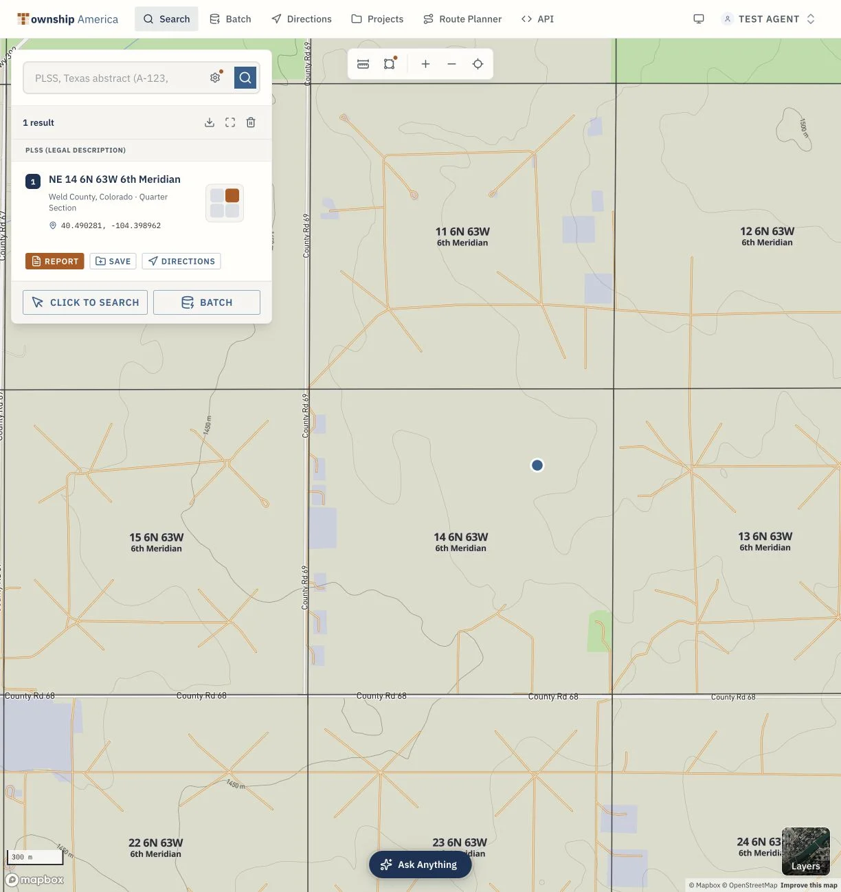
The output reads as a complete description. For example, a coordinate in Weld County, Colorado returns a result in the form T5N R66W Sec 14 NENW, 6th Principal Meridian. A point in western Oklahoma returns something like T14N R10W Sec 27, Indian Meridian. Township America calculates these positions from official BLM survey data, so the answer honors the actual recorded survey rather than a grid estimated by formula. Check the returned polygon against the recorded plat before relying on a boundary position.
Running a reverse lookup in Township America
The PLSS converter handles both directions from one screen.
- Open the converter and switch to coordinate input.
- Enter latitude and longitude in decimal degrees, for example 40.19, -104.60. If your device shows degrees, minutes, and seconds, convert to decimal degrees first.
- Read the result. The converter returns the township, range, section, aliquot part, principal meridian, and county for that point.
You can also click a location directly on the map to read its legal description, which is faster when you are eyeballing a boundary rather than typing a precise coordinate. Single reverse lookups are available on every plan.
There is one coverage detail worth knowing if you work in Texas. Texas is not a PLSS state: it uses the Abstract, Block, and Survey grid recorded by the General Land Office. Township America resolves that grid in reverse too, returning the abstract and survey a coordinate falls in, free on every tier alongside PLSS. No other PLSS converter reads the Texas grid, so a title team working across the New Mexico line into Texas can run both from the same tool.
Getting the parcel boundary, not just the point
A coordinate tells you where you are. The legal description tells you which parcel you are in. For most downstream filings you want the parcel itself, drawn to its real edges.
Every section and quarter-section lookup can return a full GeoJSON polygon of the parcel boundary, reflecting the BLM survey outline rather than a single centroid point. That polygon drops straight into QGIS, ArcGIS, or Leaflet. On the Pro plan you can draw and export the boundary as a PDF for a report or filing. On the Business plan you get structured GIS exports, including Shapefile, GeoJSON, and DXF, which is what a survey shop needs to pull the parcel into CAD.
Where the result gets used
The reverse workflow is not an academic exercise. It is a daily step in several jobs:
- APD and permit filings. A geologist pins a proposed well site as a coordinate. Before the drilling application can move, that point has to be recorded as a section, township, and range. Land teams that do this at volume often run it through the REST API, described in our writeup on how landmen use the API for APD workflows.
- Title and lease review. A coordinate from a plat or a field note has to be tied back to the legal description on record before it can be checked against a chain of title.
- Crop insurance and ag records. Federal crop programs reference land by quarter-section. A field boundary collected as latitude and longitude has to resolve to the correct quarter-section before it goes on a form.
- GIS pipeline validation. Analysts merging field-collected points with deed-sourced records need every row in the same format. Reverse lookup standardizes coordinate data into legal descriptions so the two sources reconcile.
Running it at scale
A single lookup is a screen. A book of policies or a well list is a spreadsheet. Township America accepts a CSV or Excel upload and converts thousands of coordinates in one pass on the Business plan, with structured exports for the results. For software integration, the separate REST API offers Build, Scale, and Enterprise request tiers, with free Python and TypeScript clients. The remote MCP connector is included on Pro and Business, so an AI agent can resolve coordinates inside a larger workflow.
If you are holding a coordinate that needs a legal description, open the converter and switch to reverse mode. For batch work or API access, see the plans. The lookup finishes in about two seconds, and you get a description you can paste straight into a filing, a title note, or a GIS record.