GPS to Legal Description: The Complete Guide to Reverse PLSS Lookup
Convert latitude and longitude to a PLSS legal description using reverse lookup. Step-by-step guide for surveyors, landmen, and GIS analysts.
You are standing in a field in eastern Colorado with a latitude and longitude on your phone screen. The permit application on your clipboard needs a legal land description: Section, Township, Range, and principal meridian. You need to go from GPS to legal description, and scrolling through BLM plat maps is not how you want to spend your afternoon.
This is a reverse PLSS lookup: taking a set of coordinates and finding which Section, Township, and Range that point falls in. It is the opposite of the more common forward conversion, and it comes up constantly in fieldwork, drone operations, regulatory filings, and GIS cleanup.
Why Reverse Lookup Matters
The Public Land Survey System organizes land across 30+ US states into a grid of Townships, Ranges, and Sections. Most land records, leases, permits, and deeds reference parcels using this grid. But field data (from handheld units, drone flights, vehicle trackers, or phone apps) comes in as latitude and longitude.
That mismatch creates a translation problem. Every time someone collects a coordinate in the field and needs to record it as a legal description, they need a GPS to legal description conversion.
A few situations where this comes up every week:
- Drone operators log flight coordinates and need to file FAA Part 107 waivers referencing the PLSS location
- Field inspectors record GPS positions during pipeline walks or environmental assessments, then write reports using legal descriptions
- Landmen receive latitude and longitude from geologists and need the Section-Township-Range for APD filings (see how land departments handle this at scale with the API)
- County assessors reconcile GPS-tagged field data with parcel records indexed by legal description
In each case, the workflow is the same: coordinates in, legal description out.
How Reverse PLSS Lookup Works
A reverse lookup takes your latitude and longitude and determines which PLSS grid cell contains that point. The system works through a hierarchy:
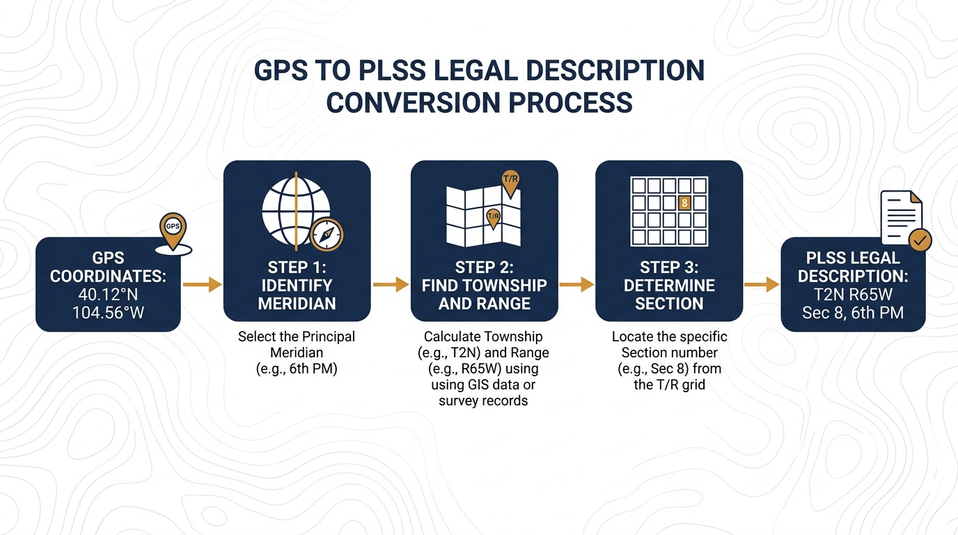
- Identify the principal meridian: Your coordinates fall within one of the 37 principal meridian systems. The 6th Principal Meridian covers most of Kansas, Nebraska, Colorado, and Wyoming. The Indian Meridian covers most of Oklahoma. Each meridian has its own baseline and grid.
- Find the Township and Range: From the meridian's baseline and principal line, the system counts 6-mile-wide rows (Townships) north or south and 6-mile-wide columns (Ranges) east or west to locate the correct Township-Range intersection.
- Determine the Section: Within the 36-square-mile Township, the system identifies which of the 36 one-square-mile Sections contains your point.
- Narrow to the quarter: If you need 160-acre or 40-acre precision, the lookup identifies the quarter section (NE, NW, SE, SW) and quarter-quarter section.
The result is a complete legal description like T3S R68W Sec 22 SENE, 6th Principal Meridian, placing a 40-acre parcel in the foothills of Jefferson County, Colorado.
Step-by-Step: Converting Coordinates to a Legal Description
Using Township America's Converter
The fastest method is Township America's PLSS converter, which handles both forward and reverse lookups.
- Open the converter at townshipamerica.com/plss-converter
- Switch to reverse mode: select the coordinate input option
- Enter your latitude and longitude in decimal degrees (e.g., 35.87, -98.12)
- Read the result: the converter returns the Section, Township, Range, principal meridian, quarter section, and county
For the coordinates 35.87°N, 98.12°W, the reverse lookup returns T4N R7W Sec 15, Indian Meridian, a location in Blaine County, Oklahoma.
If you prefer a visual approach, the interactive map lets you click any point to get its PLSS description. The full reverse lookup walkthrough covers map-based lookups and mobile field use in detail.
Using the API
For teams processing hundreds of coordinates, the Township America API accepts latitude and longitude and returns the full legal description as structured data:
curl "https://developer.townshipamerica.com/search/reverse?lat=35.87&lon=-98.12" \
  -H "X-API-Key: YOUR_API_KEY"
The response includes the legal description components, county, state, and a GeoJSON polygon of the section boundary. The API handles single lookups and batch requests, useful when you have a spreadsheet of field coordinates that all need PLSS descriptions.
Common Use Cases
Drone Flight Logging
Commercial drone operators in PLSS states collect flight coordinates from their controller or planning software. FAA waivers, state permits, and client deliverables often require the legal description of the survey area. A GPS to legal description conversion turns a flight log coordinate like 40.12°N, 104.56°W into T2N R65W Sec 8, 6th Principal Meridian, a location in Weld County, Colorado. For a full walkthrough of this workflow, including how to handle multi-section survey extents, see the guide to connecting UAV data to PLSS legal descriptions.
APD and Permit Filings
When a geologist pins a proposed well site on a map, the latitude and longitude need to become a legal description before the permit paperwork can move forward. The forward conversion guide covers the opposite direction: going from a description on a deed to coordinates for navigation.
GIS Data Cleanup
GIS analysts working with datasets that mix coordinate formats and legal descriptions need reverse lookup to standardize records. A parcel layer might have GPS positions for field-collected points but legal descriptions for deed-sourced records. Reverse lookup brings everything into the same format.
Tips for Accurate Results
Use decimal degrees. Most reverse lookup tools expect coordinates in decimal degrees (35.87, -98.12), not degrees-minutes-seconds. If your GPS device shows DMS format like 35°52'12"N, convert before entering.
Check the meridian. Verify that the principal meridian in the result matches what you expect for that area. A point near a meridian boundary could theoretically fall in either system; the converter resolves this, but it is worth confirming.
Understand precision limits. A reverse lookup tells you which Section and quarter section a point falls in. It does not replace a licensed land survey for boundary determination. The PLSS grid defines approximate boundaries; actual monument locations established by the original GLO surveys are the legal authority.
Account for survey irregularities. Not every Township is a perfect 6×6-mile square. Convergence of meridians, fractional sections along boundaries, and historical survey errors mean some Sections are larger or smaller than 640 acres. The converter accounts for these irregularities using official BLM data.
Try It Now
If you have a latitude and longitude that needs a legal description, open the converter and switch to reverse mode. Single lookups are included on every plan. For batch processing or API access, see pricing.
The conversion takes under two seconds. Your clipboard gets a legal description you can paste directly into a permit, report, or land record.