Colorado PLSS Guide: DJ Basin, Piceance Basin, and the 6th Principal Meridian
Read a Colorado PLSS legal description across three principal meridians: the 6th PM for the DJ Basin, the Ute PM for the Piceance, plus Energy pack well data.
A Denver-Julesburg Basin landman confirming acreage in Weld County has the same problem as one working the Bakken or the Powder River, with one extra wrinkle. Before a Colorado PLSS legal description goes onto a title opinion or a permit, it has to point at the right section, and in Colorado that means naming the right principal meridian first. Colorado is not a single-meridian state. Three principal meridians survey the state, and a Township and Range number that reads cleanly can still sit under the wrong one. This guide walks through how Colorado's grid is built, where the DJ Basin and Piceance Basin sit inside it, and why the meridian line is the part of a Colorado description you cannot leave off.
Three meridians, not one
Wyoming is easy in exactly the way Colorado is not: all of Wyoming counts from the 6th Principal Meridian, so the meridian never changes the answer. Colorado runs on three.
- The 6th Principal Meridian governs the eastern plains and the Front Range, including the entire Denver-Julesburg Basin. Its initial point is a monument on the Kansas-Nebraska border in Republic County, Kansas, the same point Wyoming and Nebraska survey from.
- The Ute Principal Meridian governs a compact block of western Colorado. Its initial point sits near Grand Junction, and its townships cover much of the Grand Valley and parts of the Piceance Basin country.
- The New Mexico Principal Meridian reaches up from the south to cover a portion of southern Colorado, including San Luis Valley ground.
The consequence is practical. Township 2 North, Range 66 West exists under the 6th Principal Meridian, but a Township and Range pair can be reused under the Ute or New Mexico origins, and those are separate grids anchored to separate initial points. This means a Colorado PLSS legal description without a meridian is not a location. It is a location under three possible readings, and only one of them is the parcel you meant. For a refresher on how a principal meridian anchors the whole count, the 6th Principal Meridian reference covers the initial point and baseline.
Denver-Julesburg Basin: where the volume is
The DJ Basin is Colorado's busiest oil and gas region, and it reads entirely off the 6th Principal Meridian. The core sits in Weld County, with the play extending into Adams, Broomfield, and Boulder counties and north toward the Wyoming and Nebraska lines. The Wattenberg field anchors it, and horizontal development targets the Niobrara and Codell intervals.
Read a DJ Basin description the way the grid is built. Take T2N R66W Sec 15, 6th Principal Meridian, which places you in the Wattenberg corridor of Weld County. T2N is the second tier of townships north of the baseline. R66W is the 66th range west of the meridian. Sec 15 is one of the 36 one-mile sections inside that township. Add an aliquot part such as SW¼NE¼ Sec 15 and you read it right to left: the southwest quarter of the northeast quarter, a 40-acre parcel, not 160. On a horizontal spacing unit that 40-acre call is often the pooled tract that carries the working interest, so the aliquot part is not optional detail.
Because the DJ Basin is single-meridian ground, Township and Range do the entire job of locating the parcel, which is exactly why a transposed digit is expensive. R66W and R96W are 30 ranges apart, roughly 180 miles, and both are valid-looking Colorado ranges. The format clears a visual check and fails against survey data.
Piceance Basin: federal ground on a mixed meridian
Cross to the Western Slope and two things change at once. The Piceance Basin, the state's major natural gas province, sits under Garfield and Rio Blanco counties, and much of it references the Ute Principal Meridian rather than the 6th. Some townships in the region still read off the 6th Principal Meridian, so the rule on the Western Slope is to confirm the meridian on every description rather than assume it. Reading a Piceance description off the wrong origin does not just shift the parcel a few sections. It moves it to a different grid entirely.
The second change is the land itself. The Piceance carries a heavy concentration of federal surface and federal minerals, managed by the Bureau of Land Management, so a large share of Piceance oil and gas work runs through federal permitting. A federal Application for Permit to Drill (Form 3160-3) needs the surface location in complete PLSS notation: Township, Range, Section, the aliquot part to at least the quarter-quarter, and the principal meridian written out. A description missing the meridian is the fastest way to earn a resubmission notice, and on the Western Slope that missing line is not a formality, because the meridian is genuinely ambiguous until you state it.
Split estate is common across this ground, where the surface may be patented to a private owner while the minerals stayed with the United States. A landman often runs two chains of title against one PLSS description, and each has its own record trail. The energy pack overview for federal leasing walks through how federal subsurface, BLM lease boundaries, and royalty data layer over the same grid.
How Township America reads a Colorado description
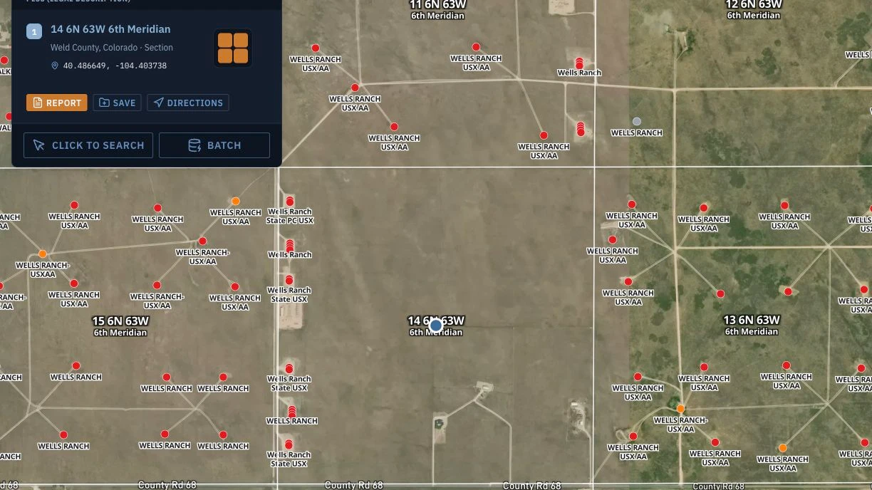
Enter a full Colorado PLSS legal description, meridian included, into Township America's Colorado converter and it returns verified latitude and longitude plus the parcel drawn on a map. The resolution runs down to the 1/256 aliquot part, which is 10 acres, and the coverage spans all 30 PLSS states and 37 principal meridians, so the Ute and New Mexico origins resolve the same way the 6th does. The math is calculated from official BLM survey data (the GCDB and CadNSDI), not estimated from a grid formula.
That distinction matters most in exactly the places Colorado is hardest. A centroid guessed from a Township-Range formula can sit over a mile off the real survey boundary, which is enough to put a surface location in the wrong section. Township America returns the actual section and quarter-section boundary as a GeoJSON polygon, reflecting the BLM survey of the described parcel, not just a center point. For a title examiner or a permit tech, the polygon is what you check the wellbore and the lease exhibit against.
Energy pack layers for Colorado
Colorado is one of the five producing states the Energy data pack covers, alongside North Dakota, Oklahoma, Wyoming, and New Mexico. The pack is $150 per month and attaches to a Pro ($20) or Business ($40 per user) plan. Once a Colorado tract is on the grid, the Energy pack overlays the data a landman otherwise queries from separate systems that do not share a map or a legal description:
- Colorado wells, drawn from the state oil and gas commission, plus federal wells from HIFLD
- BLM oil and gas leases and ONRR federal royalty totals
- Federal subsurface minerals, for split-estate reads where the data is mapped
- Nearest HIFLD pipelines (gas, NGL, and crude), with offset-operator analysis
- USGS orphaned-wells liability screening and FracFocus disclosures
Those layers roll up into a Federal Energy Report PDF for the tract. For a DJ Basin lease, that means offset wells and the operators next door on the same view as the section boundary. For a Piceance lease, it means the BLM lease footprint and the split-estate picture surface before the APD is drafted, not after. The Energy pack detail for landmen covers the full layer set and how the pack stacks on a base plan.
Correction lines and why a section is not always 640 acres
Colorado's grid does not close evenly everywhere, and the reason is built into the PLSS itself. Range lines run true north, so they converge as they climb toward the pole. Left uncorrected, townships would shrink to nothing far enough north. The survey corrects for this with standard parallels (correction lines) laid every 24 miles, where the range lines are re-established at their full six-mile spacing. The discrepancy that accumulates between two correction lines is thrown into the sections along the north and west tiers of each township.
The practical result is that sections on the northern and western edges of a township are frequently not a clean 640 acres, and their subdivisions are recorded as government lots rather than full quarter-quarters. A call like Lot 3, Sec 6, T2N R66W, 6th Principal Meridian is not 40 acres by default. Its acreage is fixed by the original GLO survey and lives in the township plat, not in the lot number. A title examiner who assumes Lot 3 equals NW¼NW¼ will misstate the estate, and on a producing well that error carries into the royalty decimal. When a Colorado description carries a lot number, pull the plat acreage before you rely on it.
This is a general PLSS behavior, not a Colorado quirk, but it lands hard in Colorado because the state combines three meridians with long north-south township runs. The same discipline that keeps a Wyoming filing clean applies here: the Wyoming Powder River guide covers government lots on the 6th Principal Meridian in a neighboring Energy pack state, and the Wyoming state reference shows the single-meridian case Colorado is the exception to.
Put a Colorado description on the map
Colorado rewards the same habit every PLSS state does, plus one it enforces harder than most: name the meridian, every time, on every description. The DJ Basin reads off the 6th Principal Meridian, the Piceance runs on a mix of the Ute and the 6th, and the southern counties bring in the New Mexico Principal Meridian. A Range number without a meridian is not a location in a three-meridian state.
Paste any Colorado PLSS legal description into the Colorado PLSS converter and you get verified latitude and longitude plus the section polygon in seconds, resolved against BLM survey data. Running a multi-section project across a DJ Basin program or a Piceance lease block? On the Business plan, unlimited batch conversion turns a CSV of descriptions into coordinates and boundaries in one pass, with structured exports (CSV, KML, Shapefile, GeoJSON, and DXF) to drop straight into QGIS or ArcGIS. See the plans and Energy pack pricing for the base plan plus the pack that carries Colorado well data.