Texas Coastal Hazard Layers in the Texas Pack: Bay Tracts, Erosion Risk, and Shoreline Change for Coastal Property Diligence
Texas coastal property erosion and GLO bay tract diligence: what the Texas pack coastal layers show for bay tracts, oyster leases, erosion, and shoreline change.
A coastal Texas tract raises questions that county appraisal records were never built to answer. A buyer looking at a bay-front parcel in Matagorda or Aransas County wants to know whether the land sits next to a state-managed bay tract, how far the shoreline in front of it has moved over the past few decades, and whether an oyster lease sits offshore of the boundary. Those are the recurring questions in Texas coastal property erosion and GLO bay tract diligence, and they rarely resolve from a deed and a plat alone. This post explains what the Texas pack coastal layers cover, how you pull them for a specific Abstract and Survey parcel, and where the data stops so you know what still needs a surveyor or a title opinion.
Where Texas coastal parcels come from
Most of Texas was never laid out on the PLSS rectangular grid. Coastal tracts are described by the Abstract, Block, and Survey system: an abstract number tied to an original land grant survey (for example, a description reading "A-45, B. Milam Survey, Abstract 45, Matagorda County") rather than a section, township, and range. Township America resolves that Abstract, Block, and Survey (GLO) grid to coordinates directly, free on every plan, in the same search box that handles PLSS. That resolver is where coastal diligence begins: you locate the upland survey first, then read the hazard layers against it.
Bay tracts are different from upland surveys. The submerged and near-shore land along the Texas coast is managed by the Texas General Land Office (GLO), and a bay-front parcel can sit next to, or in places overlap, that state-managed area. Knowing which side of that line a boundary falls on changes who controls surface access and what uses are permitted.
What the Texas pack coastal layers include
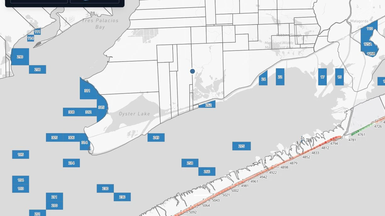
The coastal layers ride on top of the free grid resolver as part of the Texas data pack. The pack carries 18 Texas layers in total, and four of them are coastal:
- Bay tracts: the GLO-managed bay and submerged-land areas along the coast.
- Oyster: mapped oyster lease and reef areas offshore of the shoreline.
- Erosion: coastal erosion hazard areas.
- Shoreline change: how the shoreline position has moved over time.
These draw on Texas GLO records and Texas state coastal agency sources. They sit in the same pack as the GLO leases, PSF and state-agency lands, RRC wells, and pipeline layers that serve the oil, gas, and ranch verticals, so a coastal parcel and an inland lease read from one workspace.
Pulling coastal data for a specific parcel
The workflow is the same one you would use for any Texas tract, with the coastal overlays turned on:
- Enter the Abstract and Survey description (the abstract number, survey name, and county) into the search box.
- The grid resolver returns coordinates and the parcel boundary on the map.
- Read the bay tract, oyster, erosion, and shoreline change layers against that boundary.
Because the resolver returns the parcel and not just a pin, you can see whether the boundary touches a bay tract or falls inside an erosion hazard area rather than guessing from a nearby address. For a full session you can stack the coastal read with the GLO lease and PSF layers and export the result as a Combined Parcel Report PDF.
Reading erosion and shoreline change, and their limits
Shoreline change and erosion layers describe how a stretch of coast has behaved, which is exactly the context a buyer or lender wants before a coastal transaction closes. A parcel in a high-erosion stretch of Galveston, Matagorda, Calhoun, Aransas, or Nueces County carries a different risk profile than one behind a stable shoreline, and the layers let you see that difference on the map instead of inferring it.
Be clear about what these layers do and do not do. They are a diligence pre-screen, not a survey, a jurisdictional determination, or a legal opinion on where the boundary or the state ownership line actually falls. Erosion and shoreline change data reflect historical measurement: they describe past movement and do not predict a specific future setback for a specific lot. When a transaction turns on the exact position of a boundary or the state-managed line, that still calls for a licensed surveyor and a title examination. Use the coastal layers to know which questions to ask and where to spend that effort.
Bay tract status and what it signals
When a parcel sits next to a GLO-managed bay tract, that flags questions a buyer should raise early: what surface access the state controls, whether an oyster lease sits offshore of the boundary, and what uses are permitted along the water. The pack shows you the proximity so those questions surface during diligence rather than after closing.
Putting it together
For coastal Texas diligence, the free Abstract and Survey resolver locates the tract, and the Texas pack coastal layers give you the bay tract, oyster, erosion, and shoreline change context around it, with the GLO lease and PSF layers available in the same session. The Texas pack is $100 per month on top of a Pro plan at $20 per month, and no other PLSS converter resolves the Texas grid at all, let alone the coastal layers on top of it. See the Texas pack on the pricing page, read how the tool fits real estate and oil and gas work, or start from the converters to resolve a coastal Abstract and Survey description. Confirm the boundary and the state line with a surveyor and title before you close, and use the coastal layers to walk in knowing what to check.