Metes and Bounds vs. PLSS: Which System Covers Your State?
Metes and bounds vs PLSS, learn which legal description system your state uses, how each works, and when you need a converter vs. a surveyor.
Every deed in the United States describes land using one of two systems, and which one you encounter depends almost entirely on which state the property sits in. If you work in real estate, title, or land management, knowing the difference between metes and bounds and the Public Land Survey System (PLSS) is not optional. A deed description that makes perfect sense in Virginia looks nothing like one from Kansas, and misreading either one can derail a closing, delay a permit, or send a field crew to the wrong parcel.
Here is how the two systems work, which states use which, and how to handle legal descriptions under both.
Two Systems That Divide America
The split goes back to the founding of the country. The original thirteen colonies described land before any national survey existed. Property boundaries followed rivers, ridgelines, old stone walls, and trees, whatever landmarks the original grantees and surveyors referenced. That approach is metes and bounds, and it remains the legal description system in those states today.
After the Revolutionary War, Congress needed a way to survey and sell the vast territory west of the Appalachians. The result was the Public Land Survey System, established by the Land Ordinance of 1785. Instead of tracing irregular boundaries from landmarks, the PLSS imposed a rectangular grid of townships, ranges, and sections, measured outward from 37 principal meridians. Every parcel in a PLSS state can be described by its position on that grid.
The two systems never merged. They still run in parallel, and the boundary between them is the boundary between states.
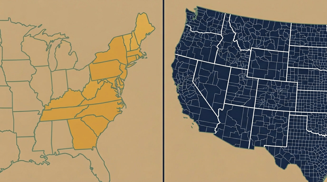
Which 30 States Use PLSS, and Which 20 Use Metes and Bounds
PLSS states (30): Alabama, Alaska, Arizona, Arkansas, California, Colorado, Florida, Idaho, Illinois, Indiana, Iowa, Kansas, Louisiana, Michigan, Minnesota, Mississippi, Missouri, Montana, Nebraska, Nevada, New Mexico, North Dakota, Ohio, Oklahoma, Oregon, South Dakota, Utah, Washington, Wisconsin, and Wyoming.
Metes and bounds states (20): Connecticut, Delaware, Georgia, Hawaii, Kentucky, Maine, Maryland, Massachusetts, New Hampshire, New Jersey, New York, North Carolina, Pennsylvania, Rhode Island, South Carolina, Tennessee, Texas, Vermont, Virginia, and West Virginia.
The pattern is straightforward: states carved from the original colonies and their grants use metes and bounds. States surveyed under federal authority after 1785 use PLSS. Texas and Hawaii are exceptions. Texas kept its own land grant system from the Republic era, and Hawaii has a unique system rooted in its kingdom-era land divisions.
Ohio is the one state that straddles both worlds. It was the first testing ground for the rectangular survey, but parts of the state (including the Virginia Military District) still use metes and bounds descriptions from pre-PLSS grants. A title examiner in Ohio may encounter both systems in the same county.
How a Metes and Bounds Description Works
A metes and bounds description traces the boundary of a parcel by starting at a defined point and following a series of calls (compass bearings and distances) around the perimeter until the description closes back at the starting point.
Here is a simplified example from a Virginia deed:
Beginning at an iron pin on the south side of Route 11, thence S 45° 30' E, 400 feet to a stone; thence S 44° 30' W, 600 feet to an oak tree; thence N 45° 30' W, 400 feet to an iron pin; thence N 44° 30' E, 600 feet along the south side of Route 11 to the point of beginning.
Each segment has three elements: a direction (compass bearing), a distance, and a terminus (the monument or marker at the end). The description depends on physical landmarks (iron pins, stones, trees, roads, creek banks). If a monument has moved, been destroyed, or was described ambiguously in the original deed, the boundary can be disputed.
Metes and bounds descriptions are inherently unique to each parcel. There is no grid, no numbering system, and no way to look up a parcel by a standardized identifier. You need the deed itself to know where the land is.
How a PLSS Description Works
A PLSS description identifies a parcel by its coordinates on the rectangular grid. No compass bearings, no monuments, no tracing a boundary. The description reads like an address on a grid system, because that is exactly what it is.
Here is a typical PLSS description from a Kansas deed:
NW¼ SE¼ Sec 14, T15S R3W, 6th Principal Meridian
That identifies the northwest quarter of the southeast quarter of Section 14, Township 15 South, Range 3 West, referenced to the 6th Principal Meridian. It is a 40-acre parcel, and any surveyor, title examiner, or GIS analyst can locate it immediately on the grid without reading a chain of bearings.
The hierarchy runs from large to small: principal meridian → township → section → quarter section → quarter-quarter section. Each level subdivides the one above it, down to parcels as small as 10 acres (1/256th of a section). The grid is the same across all 30 states; only the principal meridian changes.
How to Identify Which System Your Deed Uses
If you are looking at a legal description and are not sure which system it uses, here are the markers:
It is PLSS if you see:
- Township and Range notation (T4N R5E, Township 12 South Range 7 East)
- Section numbers (Sec 14, Section 22)
- Quarter section calls (NE¼, SW¼ NW¼, NENE)
- A principal meridian reference (6th Principal Meridian, Indian Meridian, Willamette Meridian)
It is metes and bounds if you see:
- Compass bearings (N 45° 30' E, S 12° 15' W)
- Distances in feet or chains (400 feet, 20 chains)
- Physical monuments (iron pin, stone, oak tree, creek bank)
- "Beginning at..." followed by a series of calls that return to the starting point
It could be either (or a hybrid) if you see:
- Lot and block references: these come from a recorded subdivision plat and can exist in both PLSS and metes and bounds states
- References to government lots: these are PLSS features found in fractional sections along rivers and lake shores
In real estate transactions, the deed will always specify which system applies. If you are working across state lines (common for firms handling mineral rights, timber, or agricultural land), you will encounter both systems regularly.
Converting Legal Descriptions: When You Need a Tool vs. a Surveyor
PLSS descriptions can be converted to latitude and longitude coordinates programmatically. The grid is standardized, the data is public (maintained by the BLM), and the math is consistent. Enter T15S R3W Sec 14 NW¼ SE¼, 6th Principal Meridian into a PLSS converter, and you get the parcel centroid in seconds. Need to process a spreadsheet of 500 legal descriptions from drilling permits? A batch conversion handles that in one upload.
Metes and bounds descriptions are harder to convert programmatically. Each one is unique: the bearing-and-distance calls, the monuments, the starting point. A metes and bounds converter can parse structured calls and plot the parcel geometry, but descriptions that reference ambiguous or destroyed monuments may need a licensed surveyor to resolve on the ground.
Here is when each approach fits:
| Situation | What you need |
|---|---|
| PLSS description from a deed or permit | Converter: enter the description, get coordinates |
| Metes and bounds with clean bearing-distance calls | Converter: parse the calls, plot the boundary |
| Metes and bounds with ambiguous monuments or gaps | Surveyor: field verification required |
| Verifying a legal description before closing | Converter first, surveyor if discrepancies appear |
| Bulk processing PLSS descriptions (title plants, permit databases) | Batch converter or API |
For real estate professionals working in PLSS states, conversion is a daily task: verifying deed descriptions, mapping rural listings, locating comparable sales. Township America's PLSS converter covers all 30 PLSS states and all 37 principal meridians, using official BLM survey data. For metes and bounds descriptions, the metes and bounds converter parses bearing-distance calls and returns parcel geometry.
Whether your deed reads "NW¼ SE¼ Sec 14, T15S R3W" or "Beginning at an iron pin, thence S 45° 30' E," the first step is the same: figure out which system you are in, then use the right tool to get from legal description to location.
Try the PLSS Converter → | Try the Metes and Bounds Converter →