North Dakota PLSS Guide: Williston Basin, Bakken Formation, and the 5th Principal Meridian
Read a North Dakota PLSS legal description in the Williston Basin: the 5th Principal Meridian, Bakken spacing units, and cross-meridian Montana work.
A landman running title on a Williston Basin lease has to be certain which section a tract sits in before the paperwork moves. In the North Dakota Bakken, where a single horizontal well can drain acreage across two or three sections, a transposed range number or a dropped aliquot part sends the whole file to the wrong owner. Reading a North Dakota PLSS legal description correctly starts with one fact that never changes here: the state is surveyed from a single principal meridian. This guide covers how that grid is built, where the productive counties sit, how sections and spacing units define a Bakken well, and why the same play is described two different ways once you cross into Montana.
The 5th Principal Meridian governs all of North Dakota
North Dakota is one of only four states surveyed entirely from one meridian. Every township and range in the state, from the Red River to the Montana line, is counted from the 5th Principal Meridian. Its initial point lies in eastern Arkansas, where the north-south meridian line and the east-west base line, first surveyed in 1815, cross in what was then swampland. That point governs surveys across Arkansas, Missouri, Iowa, and North Dakota.
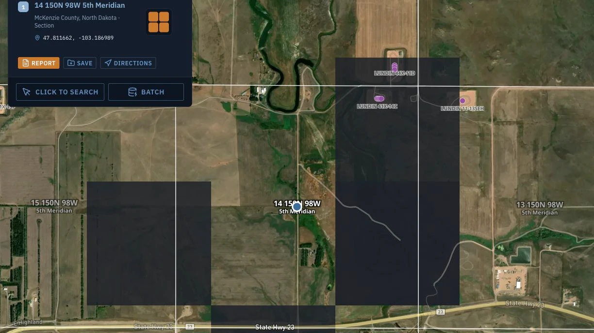
Because North Dakota sits far north and west of that initial point, two things follow. Townships carry high numbers, running roughly T129N in the south to T164N at the Canadian border, since they are counted north from a base line most of a continent away. Ranges are all counted west of the meridian, running roughly R48W to R106W. So a North Dakota description reads with a north township and a west range every time: T150N R98W Sec 14, 5th Principal Meridian places you in McKenzie County. You never have to ask which meridian applies in North Dakota, which removes one source of error but puts the whole locating job on the township and range digits. For a refresher on how townships, ranges, and aliquot parts fit together, the PLSS reference walks through the grid.
Williston Basin: where the descriptions cluster
The Williston Basin is the reason most North Dakota legal descriptions cross a landman's desk. The core Bakken and Three Forks acreage concentrates in four counties, and each spans a predictable block of the grid:
- Williams County (Williston): roughly T153N to T164N, R95W to R104W
- McKenzie County (Watford City): roughly T144N to T153N, R94W to R106W
- Mountrail County (New Town, Stanley): roughly T151N to T159N, R89W to R94W
- Dunn County: roughly T143N to T149N, R90W to R98W
These are approximate outlines, not hard boundaries, but they give you a fast sanity check. A description that reads T154N R101W Sec 22, 5th Principal Meridian should land in Williams County; if the title work says the tract is in Mountrail, the range number is worth a second look before anything is filed. Read the description the way the grid is built: T154N is the 154th tier of townships north of the base line, R101W is the 101st range west of the meridian, and Sec 22 is one of the 36 one-mile sections inside that township. Add an aliquot part such as NW¼NW¼ Sec 22 and you read it right to left: the northwest quarter of the northwest quarter, a 40-acre parcel, not 160.
How sections and spacing units define a Bakken well
A section is one square mile, about 640 acres, and 36 sections make up a survey township. In a vertical-well world, that section grid maps cleanly onto ownership and onto the well. The Bakken changed the second half of that.
North Dakota Bakken and Three Forks wells are horizontal. A single lateral commonly runs two miles, which means it crosses section lines. To account for that, the North Dakota Industrial Commission establishes drilling and spacing units, and the common Bakken unit is 1280 acres built from two adjoining sections (some units run 1920 acres across three). The wellbore is drilled and produced against that multi-section unit, not against one section.
Mineral ownership, however, is still described the old way. Each tract inside the unit is defined by its section and aliquot part, and production is allocated back to those tracts. This means the section and quarter calls decide who gets paid even when one wellbore drains several sections at once. For title and division-order work, the practical consequence is that you cannot stop at the unit. You have to resolve every section and aliquot inside it, because a missed 40-acre quarter-quarter is a missed owner. A tool that draws the actual section and quarter boundaries, not an approximate center point, is what lets you line the ownership tracts up against the spacing unit. This is the same offset-and-ownership problem that runs through most oil and gas title work, and it is where an accurate grid pays for itself.
Convert a North Dakota legal description in Township America
Once you have a description, the next step is putting it on the map. Enter a full North Dakota PLSS legal description, meridian, township, range, section, and aliquot, into Township America and it returns verified latitude and longitude plus the parcel drawn as a boundary. The resolution goes down to the 1/256 aliquot part (10 acres), and every result is calculated from official BLM survey data rather than estimated from a township-range formula. Coverage runs across all 30 PLSS states and 37 principal meridians, so the same tool that reads a McKenzie County tract reads a description in any other PLSS state.
Two capabilities matter for basin work specifically. First, the output is a full GeoJSON polygon of the section or quarter-section, reflecting the actual BLM survey boundary, not just a centroid point. That is what you need to overlay ownership tracts against a spacing unit. Second, the conversion runs in reverse: hand it a latitude and longitude, from a survey stake or a well surface location, and it returns the legal description, which is how you check that a filed location actually sits in the section it claims. Source data is BLM GCDB and CadNSDI. You can test the format with a single description in the general PLSS converter before running a whole lease block.
What the Energy pack returns for North Dakota
Reading the grid is half the job. Knowing what is already around a tract is the other half, and that is what the Energy pack ($150 per month, attaches to Pro at $20 or Business at $40) adds on top of the North Dakota grid. For a Williston Basin lease, entering the tract once overlays:
- Producing-state wells for North Dakota (plus Colorado, Oklahoma, Wyoming, and New Mexico) and federal wells from HIFLD
- BLM oil and gas leases and ONRR federal royalty totals
- Federal subsurface minerals for split-estate detection where they are mapped, plus offset-operator analysis
- Nearest HIFLD pipelines (gas, NGL, crude)
- USGS orphaned-wells liability screening and FracFocus disclosures
Split-estate detection is worth calling out for North Dakota specifically, because federal minerals under private surface are common across the western counties, and finding that split late is exactly the surprise the pack is built to surface early. The Energy pack rolls its layers up into a Federal Energy Report PDF for a single tract. If you are working a lease block rather than one tract, the Business plan ($40 per user) adds batch conversion and structured exports (CSV, KML, Shapefile, GeoJSON, DXF), so you can push a whole project area into QGIS or ArcGIS in one pass. Pricing and the full pack lineup are on the pricing page.
Cross-meridian: the Bakken does not stop at the state line
The Bakken play runs west past the North Dakota border into Richland and Roosevelt counties in eastern Montana, and that is where the survey system changes underneath you. Montana is not surveyed from the 5th Principal Meridian. It has its own Montana Principal Meridian, with a separate initial point near Willow Creek, Montana, established for the state's own surveys.
The practical effect on a legal description is total. On the North Dakota side you read high north townships and west ranges (T150N R98W). Cross into Richland County, Montana, and the same play is described with low township numbers and east ranges from a different reference point entirely. A tract that reads T25N R58E is a Montana Principal Meridian description, and treating its numbers as if they were 5th Principal Meridian numbers puts you hundreds of miles off. Any operator with acreage straddling the line is holding two description systems at once, and the meridian named in each description is the thing that keeps them straight. A converter that resolves both meridians against their own survey data removes the mental translation. If your work also reaches the Wyoming side of the same Energy pack region, the Wyoming PLSS guide covers the 6th Principal Meridian the same way this one covers the 5th.
Put a North Dakota description on the map
North Dakota keeps one part of PLSS work simple: one meridian, every time. It makes the rest unforgiving, because the township and range digits carry the entire locating job, and a single transposed number moves a tract across the basin. Paste any North Dakota PLSS legal description into the North Dakota converter and you get verified coordinates and the parcel boundary in seconds, from the same BLM survey data the state and federal records are built on. Add the Energy pack when the question is not just where the tract is, but what wells, leases, and split estate sit around it before you file.